Since 2018, Pixam LTD has spearheaded transformative research in diverse fields like IoT, smart agriculture drones, robotics, and remote sensing. Pioneering advancements in IoT connectivity, they’ve also revolutionized agriculture with precision drones, elevated robotics, and enabled data-driven decisions through remote sensing. Notably, some of their research projects, generously financed by the Malta Council for Science and Technology, are listed below, underscoring their commitment to innovation and collaboration. Pixam LTD’s journey embodies a commitment to innovation, propelling industries towards a more connected and sustainable future.
Beepoll Project
The project, titled BEEPOLL, represents a pioneering venture undertaken by the team, marking the advent of the third generation of studies aimed at developing sophisticated online tools. These tools are tailored to serve both national authorities and land managers, equipping them with the means to ascertain optimal sites for honeybee translocation to enhance crop pollination across Malta. Additionally, the platform offers a precise estimation of bee numbers and colonies while prioritizing strategies for the advancement of pollinator conservation efforts.
In the course of the project, the team will grapple with an array of intricate challenges. One such task involves the segmentation of vegetation landscape dynamics into distinct sub-categories, an undertaking facilitated through the adept utilization of remote sensing techniques. By harnessing data from Sentinel 2 and Pleiades satellite imagery, as well as drone-acquired aerial data, the team endeavors to unravel the nuanced complexities of the landscape.
Project BEEPOLL secures its financial backing from The Malta Council for Science and Technology’s Space Funds, underscoring the significance and support accorded to this innovative and impactful endeavor.
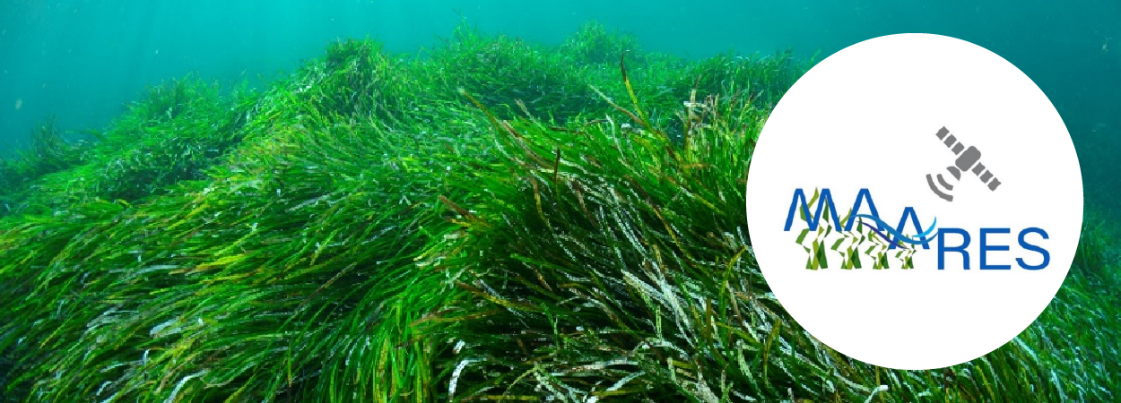
MAARES Project
PIXAM LTD is making a significant contribution to this initiative by constructing the software and abstracts necessary for its realization. The overarching goal of this endeavor is to facilitate the availability of meticulously detailed spatial maps, offering vital insights into the intricate ecology of seagrasses. These maps will be pivotal in fostering a deeper comprehension of biodiversity, ecological services, and the future sustainability of seagrasses throughout the Maltese Islands. Through the project’s outputs, a more streamlined and effective conservation management strategy for the seagrass species Posidonia oceanica (P. oceanica) will be attainable. This species is confronted by a spectrum of challenges arising from escalating human-induced influences, including the pressing impact of climate change, which collectively exert mounting pressures on these vital marine ecosystems.
The project’s core focus lies in assessing the efficacy of employing Sentinel-2 data for remote monitoring of P. oceanica within intricate shallow water contexts. Validation of Sentinel-2 image outcomes will be achieved by comparing them against underwater geo-referenced images and imagery captured by Unmanned Aerial Vehicles (UAVs). This concerted approach will culminate in the creation of high-resolution, multi-spectral orthomosaics. At the heart of this operational framework lies a comprehensive workflow, incorporating the integration of Artificial Intelligence (AI). Machine learning-based classification of the benthic environment will serve as a cornerstone, enabling the precise delineation and mapping of the extent of seagrass meadows.
PIXBRUSH Project
The recent years have borne witness to an exponential
surge in the ubiquity of Unmanned Aerial Vehicles (UAVs), more commonly
referred to as drones. These aerial marvels have established their ascendancy
across a spectrum of diverse applications, spanning the realms of agriculture,
environmental monitoring, logistics, topographical surveying, advanced 3D
modeling, security surveillance, infrastructure development, transportation,
and rigorous research pursuits. It is within this technological landscape that
the PixBrush project emerges, charting a pioneering course to amalgamate an
assemblage of diverse images procured through UAVs. These images are
subsequently channeled into a cloud-based system that wields its computational
prowess to conjure forth meticulously georeferenced orthophotos. Distinguishing
the PixBrush endeavor is its innovative layering technique, whereupon the
resultant orthophoto becomes a canvas onto which transformative changes within
both urban and rural landscapes are artfully delineated. This layer serves as a
visual narrative, adeptly highlighting shifts and modifications in a manner
that is not only facile to comprehend but also captures the nuance of the
evolving environment. The ramifications of this groundbreaking system are far-reaching,
extending its applicability across a myriad of domains, thereby underscoring
its potential to catalyze transformative shifts in the way we perceive and
interact with complex spatial transformations.